Tropical Rainstorm Could Dump A Foot Of Rain Between Houston & Wilmington NC
Travel advisory in the SE
Tropical rainstorm to bring a foot of rain along I-10 in southeast US
While the heaviest rain will fall east of Houston, the major cities of New Orleans and Mobile, Alabama, may experience significant flash flooding from a potent tropical rainstorm that could evolve into a depression.
By Alex Sosnowski, AccuWeather senior meteorologist
Published Sep 5, 2024 12:59 PM ART | Updated Sep 6, 2024 4:16 PM ART
Copied
Farmers celebrate promising fall harvest thanks to weather01:1601:52
TX: Caught on camera: Man becomes trapped in vehicle as flash flooding overtakes road in San Antonio.
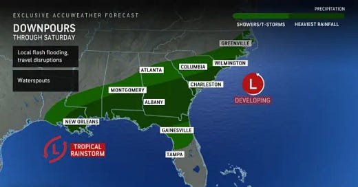
A tropical rainstorm stalling in the western Gulf of Mexico has the potential to evolve into a tropical depression or tropical storm into next week. Regardless of if or when it develops, AccuWeather meteorologists warn that enough rain will fall into Saturday night to hinder travel and lead to dangerous flash flooding in some areas of the Southeast region.
Outdoor plans, such as a day at the beach, a fishing trip or high school football games throughout the week will be impacted. Meanwhile, rising water may block some city streets and highways.
The storm has a history of heavy rainfall. It first formed near the northwestern Gulf coast late last week and wandered inland over Texas during the Labor Day weekend.

This image of the Gulf of Mexico was captured on Friday, Sept. 6, 2024, and shows a tropical rainstorm splitting in two. One piece was pushing onshore along the northeastern Gulf coast with drenching showers and thunderstorms and the other piece lingering over western Gulf waters. (AccuWeather Enhanced RealVue™ satellite)
AccuWeather designates tropical threats that have the potential to impact populated areas with flooding, rain and/or gusty winds, as well as those that could ramp up to a tropical depression or storm, to raise public awareness.
Because of its proximity to land, a quick ramp-up to a potent tropical storm is unlikely. However, because the center of circulation will remain close to the Gulf, it can continue to organize with locally stiff breezes and torrential rainfall that are often associated with a budding tropical feature. The development potential will continue into the first part of next week as the core of the storm lingers over the western Gulf.

Locally severe thunderstorms can occur along the Gulf coast, including the risk of a few waterspouts that may move onshore and become tornadoes.
Rainfall rates of 1-3 inches per hour are possible at times from southeastern Louisiana to northern Florida and southern Georgia. However, the back edge of the heaviest rain will continue to progress eastward into Saturday night.
Where this occurs over a couple of hours, major urban flooding can unfold, including in the cities of New Orleans, Louisiana, as well as Mobile, Alabama; and Pensacola, Tallahassee and Jacksonville, Florida.

A broad area where 2-4 inches of rain will fall will extend almost as far to the north as I-20 in Louisiana, Mississippi, Alabama and Georgia.
From 4-8 inches of rain is forecast to fall along Interstate 10 from Louisiana to northern Florida, as well as southern Georgia. Within this zone, pockets of 8-12 inches of rain are likely, especially in southeastern Louisiana and part of the Mississippi Panhandle. The AccuWeather Local StormMax™ rainfall is 18 inches.
Motorists shouldn't attempt to drive through flooded roads, as the water may still be rising. The force of flowing water may sweep the vehicle away, or the road surface may have been washed away beneath the water.
While the tropical rainstorm is expected to remain over the Gulf of Mexico, a separate area of low pressure is likely to develop just off the coast of the Carolinas.

As this occurs, the new low may trigger a brief period of increasing winds, enhanced rainfall and rough surf in southeastern Georgia and parts of the Carolinas before heading out to sea Saturday evening.
AccuWeather meteorologists are closely monitoring several other areas over the Atlantic basin, including one feature to the northwest of Bermuda that will swing into Atlantic Canada this weekend and the lingering feature in the western Gulf that can ramp up next week. The feature near Bermuda has the potential to evolve into a tropical depression or tropical storm in the short term.

The next two names on the list of tropical storms for the 2024 Atlantic hurricane season are Francine and Gordon.
https://www.accuweather.com/en/hurricane/tropical-rainstorm-to-bring-a-foot-of-rain-along-i-10-in-southeast-us/1688523


