Golf-ball-size hail rocks D.C.’s western suburbs during intense storm outbreak
Story by Jeffrey Halverson, Jason Samenow
Golf-ball-size hail rocks D.C.’s western suburbs during intense storm outbreak
Intense thunderstorms blasted D.C.’s western suburbs late Thursday afternoon and evening, unleashing large hail, damaging gusts and areas of flooding.
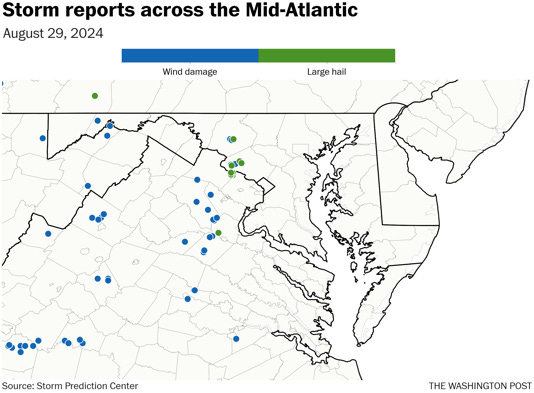
The large hail was the most unusual aspect of the storm outbreak, with multiple reports of stones the size of golf balls around Sterling, Va., and in parts of western Montgomery County in Maryland. There was even a report of hail that was 2.5 inches in diameter around Sterling, which is about the size of a tennis ball. This hail resulted in “numerous vehicles with broken windshields,” according to the National Weather Service. Hail this big is much more common in the Plains and South than the Mid-Atlantic.
Damage from large hail can be very costly; it’s not uncommon for large hail storms in the central states to become billion-dollar weather disasters. A recent study concluded that climate change will make hail bigger and its impacts more costly.
The severe storms also toppled trees in several areas west of the Beltway. There was a report of about three dozen trees brought down between Frederick and Urbana in Maryland. Several trees were also toppled in southwest Montgomery County.
Reports of wind damage and hail from thunderstorms on Aug. 29. (Ian Livingston)
To the south, there were scattered reports of downed trees in Fauquier County, but flooding was the primary storm impact, as several inches of rain fell in a short time. Multiple reports of flooding came in from Fauquier and Prince William counties. Notably, the ramp from Route 29 to Interstate 66 was closed because of high water in Gainesville, Va. Floodwaters also spread across a portion of Route 1 in Dumfries, Va.
How the hailstorm unfolded
Thursday’s hailstorm originated from a large cell that tracked from southwest to northeast between Sterling, Va., and Frederick, Md. A radar snapshot of the storm about 5:14 p.m. local time is shown below.
Radar image of intense, hail-producing storm at 5:14 p.m. Thursday. (Radarscope)
This image shows a core of very intense rain and lightning between Poolesville and Germantown (red shades) in Maryland. Embedded on the Poolesville side is a bright purple region, indicating the mixture of rain and golf-ball-size hail. We marked the most extreme value of “radar return” power, 70.5 dBZ, in this low-level scan. Such high-energy returns are very rare in the Washington region, which suggests large “targets” for radar energy to bounce off. Basically, the purple region is a classic radar signature of a storm with large hail.
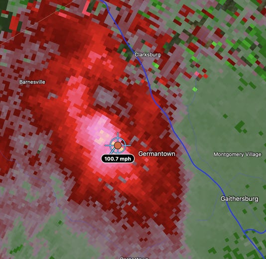
Damaging gusts accompanied the volley of hail. We use another attribute of weather radar, the Doppler measurement of winds, to identify wind cores. The damaging wind signature is shown in the next image, around the same time.
Doppler-radar estimated wind speeds at 5:14 p.m. Thursday. (Radarscope)
The region of bright-pink and peach-colored pixels just west of Germantown shows a pocket of extremely fast outflow from the storm, not far above the ground, moving from the southwest. Most values were in the 70-plus mph range, but one small region indicated flow as strong as 101 mph. Not all of that momentum may have descended to the ground
The siege of wind and large hail was short-lived and concentrated over a very small area, tied to this single cell. The atmosphere over the area Thursday afternoon was very unstable, with large values of “buoyant energy” feeding cloud updrafts. As much as a third of that energy was concentrated in the critical layer for hail growth, in mid-levels of the cloud, where supercooled water drops and ice particles coexist. This led to great vertical acceleration of the updraft; a strong updraft is needed to suspend stones large enough to grow to golf-ball-size. As this enormous core of water and ice collapsed, that action probably pushed a surge of air toward the ground — creating the violent outflow of damaging wind we term a downburst.
Below you can see several scenes of the hail from social media.
Storms were prolific rain and lightning producers
The storms in the District’s southwest suburbs in Northern Virginia didn’t produce as much hail, but were prolific producers of rain and lightning. Because of a lack of atmospheric steering currents, the storms stalled and unleashed torrents of rain and vivid bolts for hours in Fauquier, Prince William and Stafford counties.
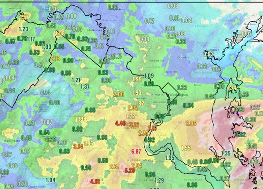
Rainfall amounts inside the Beltway were generally between half an inch and an inch, but climbed to 2 to 5 inches or more in central and southern Fauquier, Prince William and Stafford counties. Stafford Regional Airport reported 6.87 inches.
Rainfall observed on Thursday. (NWS)
The deluge was accompanied by a siege of lightning. Eyewitnesses on social media described “hours of flashes and rumbles.” Veronica Johnson, the chief meteorologist for ABC7, reported “over 400 lightning strikes in a just a few minutes.” A personal weather station registered 1,500 lightning strikes.
Another round of strong thunderstorms is possible in the D.C. region Saturday evening.
https://www.msn.com/en-us/weather/other/golf-ball-size-hail-rocks-d-c-s-western-suburbs-during-intense-storm-outbreak/ar-AA1pIH0W


