Francine Forms
Chevron Gulf Coast Workers To Get A Rain Day Off, Hurricane alert from Brownsville to Mobile, AL
Tropical Storm Francine Forms In The Gulf; Hurricane, Storm Surge Watches Issued
By weather.com meteorologists
2 hours ago
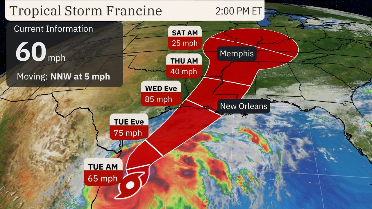
Tropical Storm Francine has formed in the western Gulf of Mexico and is forecast to be a hurricane threat to parts of Louisiana by Wednesday.
The National Hurricane Center designated Tropical Storm Francine Monday morning, the sixth named storm of the 2024 Atlantic hurricane season, and first storm in almost three weeks.
Here's the latest status of this system: Francine is centered over 400 miles south of Cameron, Louisiana, and is moving slowly north-northwest.
Most of the rain from this system is located offshore at this time, but some bands have wrapped into parts of South Texas, at times.
Some minor coastal flooding was recorded by tidal gauges along the Texas coast Monday morning from Port O'Connor southward.
(MAP TRACKER: Spaghetti Models And More)
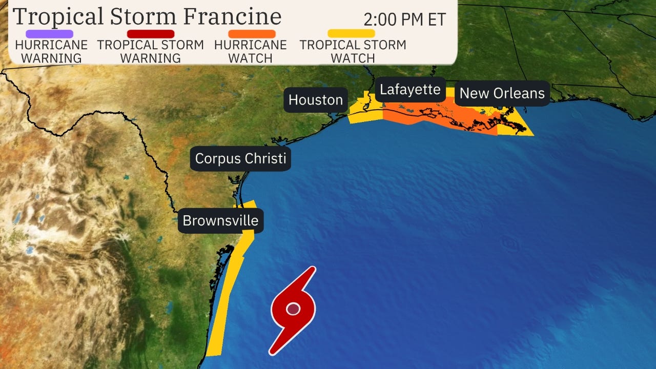
Where watches and warnings are in effect: The map below shows where hurricane and tropical storm watches and/or warnings are currently in effect.
A hurricane watch has been issued from Cameron to Grand Isle, Louisiana. This watch is usually issued 48 hours ahead of when conditions deteriorate to make preparations dangerous.
A storm surge watch has also been issued from High Island, Texas, east of Galveston Bay, to the Mississippi-Alabama border, including Vermilion Bay, Lake Pontchartrain and Lake Maurepas. This means life-threatening storm surge is possible in these areas within 48 hours.
Tropical storm watches are in effect from northeast Mexico to Port Mansfield, Texas, and also from east of Galveston Bay to Cameron, Louisiana, and from near Grand Isle, Louisiana, to the Louisiana-Mississippi border, including Lake Pontchartrain. This means tropical storm force winds are possible.

Forecast track and intensity: Francine is forecast to strengthen into a hurricane before it makes landfall somewhere along the Louisiana coast later Wednesday. It is soon expected to track over a pool of very warm Gulf water that would help it intensify. But it may also face increasing wind shear and possibly some drier air near the Gulf Coast that may cap off its intensity near landfall.
Impacts from Francine, however, will spread north along the Texas and Louisiana coasts well ahead of landfall. After landfall, the system will spread rainfall through parts of the South to as far north as the mid-Mississippi and Ohio valleys late this week.
(MORE: What The Forecast Cone Means)

Potential Impacts
Flooding Rainfall
Bands of heavy rain could begin to lash parts of the coast from South Texas to Louisiana, Mississippi and southern Alabama as soon as Tuesday and will continue in some areas near the coast through Wednesday night or early Thursday.
Rainfall totals from Francine could reach 4 to 8 inches, with local amounts to 12 inches, from the coast of far northeast Mexico to the far southern Texas coast and portions of southern Louisiana and southern Mississippi through Thursday morning.
The rain is going to be falling on saturated soil from recent heavy rains across the region, and flash flooding is possible.
read more at
https://weather.com/storms/hurricane/news/2024-09-09-tropical-storm-francine-louisiana-texas-gulf-hurricane


